When it comes to protecting your home or business against the devastating consequences of flooding, flood insurance is a crucial safeguard. Yet many property owners in Idaho, particularly in growing communities like Nampa, are surprised to learn that obtaining or renewing their flood insurance may hinge on a specific document: the elevation certificate. Although it might sound technical or bureaucratic, this certificate holds significant power in shaping your insurance rates, ensuring compliance with local and federal requirements, and confirming your property’s level of risk within a FEMA flood zone. Understanding what an elevation certificate is, how it is used, and why you may need to work with a certified land surveyor in Nampa to get one can save you money and headaches in the long run. Let’s explore how this critical document impacts flood insurance requirements and what you should know to stay protected.
What Is an Elevation Certificate?
An elevation certificate is a standardized document prepared by a licensed professional—typically a certified land surveyor, engineer, or architect—that records your building’s elevation information in relation to the base flood elevation determined by FEMA. In simple terms, it measures how high your building is compared to the level floodwaters are expected to reach during a major flood event. This information is critical for insurance companies when calculating your risk and determining appropriate premiums for your flood insurance policy.
In Idaho communities like Nampa, where development near rivers and other waterways continues to expand, understanding your flood risk has never been more essential. An elevation certificate documents key details such as the building’s lowest floor elevation, location, and the presence of basements or crawl spaces, which all factor into a more accurate flood insurance quote. Without an elevation certificate, insurers may assume the worst-case scenario for your building, potentially resulting in higher flood insurance premiums.
Why Flood Insurance Requirements Depend on Elevation
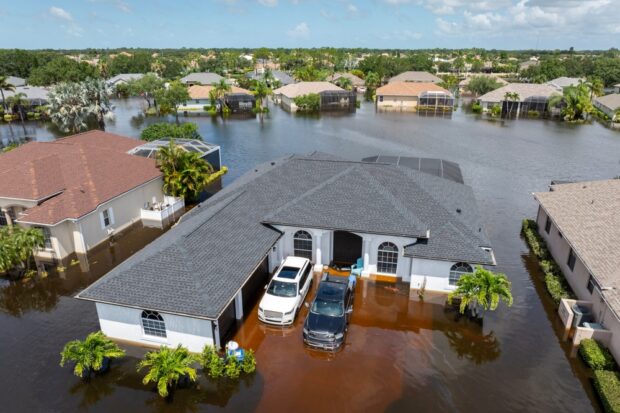
Flood insurance requirements vary depending on whether your property is located in a FEMA-designated flood zone. FEMA flood zones categorize areas by risk, ranging from low-risk Zone X to high-risk Special Flood Hazard Areas (SFHAs) like Zone AE or Zone VE. If your property is in a high-risk zone, your mortgage lender may require you to carry flood insurance as a condition of your loan. To properly determine your rates and comply with National Flood Insurance Program (NFIP) guidelines, an elevation certificate is often necessary.
For example, in Nampa, local authorities rely on FEMA flood zone maps to guide development and assess risk. When purchasing flood insurance in these higher-risk areas, the insurance company will typically request an elevation certificate to verify whether your home’s lowest floor is above or below the base flood elevation. If your building is elevated higher than FEMA’s baseline, you could receive substantial discounts on your flood insurance premium. On the other hand, if your elevation is below the base flood elevation, you may face higher premiums, but at least you will have a clear understanding of the risk and can take mitigation measures if needed.
It’s also worth noting that floodplain management regulations enforced by local governments, including those in Idaho, often incorporate elevation certificate data to ensure buildings are compliant with minimum construction and safety standards. In short, the elevation certificate is a crucial puzzle piece that supports both your flood insurance requirements and community flood management practices.
How to Obtain an Elevation Certificate in Idaho
If you need an elevation certificate in Idaho, the first step is to hire a certified land surveyor in Nampa or your local community. These professionals are trained to accurately measure the critical elevation details FEMA requires. They will visit your property, conduct field measurements, and complete FEMA’s standardized elevation certificate form.
Many property owners wonder whether a certificate from a previous owner can be reused. The answer depends on whether the structure or its surroundings have changed. If the building hasn’t been altered and no major changes have occurred to the land, you may be able to use an existing certificate. Otherwise, a new survey will be needed.
The cost of an elevation certificate can vary based on property size, complexity, and location, but generally ranges from a few hundred to a thousand dollars. While this might seem like an unwelcome expense, it can save you significant amounts of money over the lifetime of your flood insurance policy. A certified land surveyor in Nampa will be familiar with local floodplain regulations and can help guide you through the process, ensuring your elevation certificate meets FEMA and insurance requirements.
It’s a good idea to request a digital copy of your certificate as well as a paper one, so you can easily share it with your insurer or local floodplain manager. Keep it in a safe place, because this document is important not just for insurance purposes, but also for future construction or remodeling projects that may require proof of your building’s elevation.
How Elevation Certificates Impact Flood Insurance Costs
The most immediate benefit of an elevation certificate is the potential to lower your flood insurance premiums. Insurance companies price policies based on risk, and the more precise data they have about your property, the more fairly they can assess that risk. An elevation certificate shows whether your home is less exposed to flooding than the base flood elevation, potentially qualifying you for reduced rates.
For example, in a FEMA flood zone designated as high-risk, a home built three feet above the base flood elevation may see a dramatically lower flood insurance premium than a similar home built at or below the floodplain level. Conversely, if your certificate shows that your property is below the base flood elevation, you might face higher premiums, but you will have a clear picture of why those rates apply.
Moreover, a current elevation certificate can speed up the flood insurance purchasing process, especially if you’re buying a new property or refinancing an existing mortgage. Many lenders will request this certificate before finalizing loan documents in flood-prone areas. If you cannot provide one, the process could be delayed or result in unnecessarily high coverage costs.
For homeowners who are interested in flood mitigation projects—such as elevating their home, installing flood vents, or relocating equipment above predicted flood heights—an elevation certificate can serve as a valuable before-and-after measurement tool. By documenting improvements, you can work with your insurance agent to lower your premiums further after mitigation efforts.
Elevation Certificates and Flood Resilience in Idaho Communities
Beyond individual benefits, elevation certificates support broader community flood resilience efforts. In Idaho, and specifically in communities like Nampa that continue to grow near rivers and streams, managing flood risk is a shared responsibility. Elevation certificates give local governments and FEMA reliable data to update floodplain maps and develop more accurate risk profiles, which in turn guide infrastructure improvements, emergency planning, and zoning decisions.
For example, if a neighborhood in Nampa is consistently reporting elevation certificates showing homes well above the base flood elevation, that data can influence local authorities to revise FEMA flood zone maps, potentially removing some properties from high-risk categories. This benefits not only the homeowners who enjoy reduced insurance rates, but also the entire community by freeing up resources for higher-priority flood mitigation projects elsewhere.
Additionally, elevation certificates play a role in preserving public safety. When developers, builders, and city officials have accurate elevation data, they can plan new structures and critical infrastructure more responsibly, reducing the long-term risk of catastrophic flooding events. This is especially important as climate change leads to shifting flood patterns, making up-to-date data essential.
Ultimately, elevation certificates do more than satisfy a flood insurance requirement. They empower property owners to make informed decisions about risk, allow local authorities to develop sound flood management strategies, and help Idaho communities build resilience in the face of future challenges.
Conclusion
Whether you’re buying a new home in Nampa, renewing your flood insurance, or simply want peace of mind, taking the time to understand and secure an elevation certificate is one of the best moves you can make. By working with a certified land surveyor and staying aware of your local FEMA flood zone status, you’ll be better prepared to protect both your investment and your community for years to come.
Need a Civil Engineering Company in Nampa, ID?
Our company has experience in all aspects of surveying, including topographic and boundary measurements, construction staking projects, sub division platting, and land development. We perform all stages of the work, starting with the initial survey before having experienced engineers come in for the preliminary and final stages of planning. Then, we’ll perform the construction staking, and do the final record drawings for projects. We know our success is linked to the success of our client’s project. We will work with you to define the scope of services and set an agreed-upon budget. Call us today!