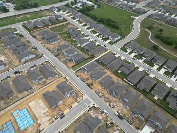
Subdivision platting is the essential first step in transforming raw land into developable lots in Canyon County. This legal and technical process divides a parcel of land into two or more lots, allowing them to be sold, developed, or improved individually. For developers aiming to invest in residential, commercial, or mixed-use projects, mastering the platting process is critical to ensuring compliance with local and state regulations.
In Canyon County, subdivision platting involves a detailed review by county officials to assess infrastructure plans, environmental impact, and zoning compatibility. The plat, a map of the subdivided land, must be designed by a licensed surveyor and approved before development permits can be issued. While the process may seem procedural, its implications are significant, affecting everything from road access to utility placement and future property sales.
Understanding the importance of subdivision platting also helps developers avoid costly setbacks. Missteps in the process could lead to rejection by planning and zoning commissions or expensive redesigns. Therefore, an early investment in quality civil engineering and land surveying in Nampa, ID, is not just advisable, it is essential.
Navigating the Subdivision Process in Canyon County
The subdivision process in Canyon County is governed by a series of steps that ensure developments meet community standards and comply with legal requirements. It typically begins with a pre-application meeting, where developers consult with the Planning & Zoning Department to discuss the feasibility of the project and receive guidance on zoning, infrastructure, and subdivision code compliance.
Following this, a preliminary plat must be submitted. This stage includes detailed drawings, proposed lot layouts, road access, and utility connections. The preliminary plat is reviewed by various departments including fire, water, sewer, and highway districts. Public hearings may be scheduled to gather community feedback, particularly if zoning changes or variances are requested.
Once the preliminary plat receives conditional approval, the final plat can be submitted. The final plat must incorporate any revisions required during the preliminary review and be accompanied by engineered construction drawings for roads, utilities, and drainage systems. This stage of the process often requires collaboration with civil engineering professionals in Nampa, ID, who ensure the project meets local infrastructure standards.
Final plat approval allows developers to begin land development in Canyon County. This includes construction of public infrastructure and, eventually, sale or construction on individual lots. Developers must also post performance bonds or financial guarantees to ensure completion of public improvements.
The Role of Land Development in Canyon County
Land development in Canyon County has grown rapidly over the past decade due to population growth and the expanding metropolitan reach of Boise. As more people move into cities like Nampa, the demand for residential subdivisions has surged, creating a wealth of opportunities for developers.
However, land development is more than just carving out lots. It includes grading, installing utilities, roads, stormwater management systems, and ensuring compliance with environmental regulations. Developers must consider the county’s Comprehensive Plan, which outlines future growth areas, zoning policies, and infrastructure expansion goals. These plans help guide development in a sustainable and structured manner.
Moreover, the geography and topography of Canyon County present unique challenges. Issues like irrigation rights, floodplain boundaries, and soil conditions often arise and require expert analysis. Effective land development in Canyon County requires coordination with surveyors, civil engineers, utility companies, and government agencies, all while managing timelines and budgets.
Economic factors also play a role. As Canyon County continues to attract businesses and residents, developers must anticipate future market trends and design subdivisions that are both functional and appealing. A successful subdivision should blend community needs with long-term investment potential, providing accessible infrastructure, desirable amenities, and efficient land use.
Importance of Civil Engineering in Nampa, ID
Civil engineering is the backbone of any successful subdivision project in Nampa and across Canyon County. From conceptual design to construction oversight, civil engineers play a pivotal role in ensuring that developments meet regulatory standards, function as planned, and serve the public efficiently.
In the context of subdivision platting, civil engineers are responsible for designing the infrastructure that supports a new development. This includes roadways, drainage systems, sewage and water lines, and stormwater management systems. In Nampa, ID, where both urban and rural characteristics influence development, civil engineers must also account for site-specific challenges like irrigation canals, elevation changes, and utility access.
The involvement of a civil engineering team begins early in the subdivision process. They work with land surveyors to assess topography, soil conditions, and site feasibility. Their designs must comply with Canyon County’s engineering standards, and often, their calculations and drawings are integral to plat approval.
Moreover, civil engineers liaise with local utility providers and regulatory bodies to ensure proper integration of services like power, water, and communication lines. Their work doesn’t end with design; they often oversee construction to confirm that the project is built according to specifications and is safe for occupancy.
Selecting a reputable civil engineering firm in Nampa, ID, is a critical decision for developers. Not only do these professionals guide projects through technical challenges, but they also help developers anticipate future requirements and avoid regulatory pitfalls that could delay or derail a project.
How Land Surveying Supports Successful Development
Land surveying is an indispensable part of the subdivision platting process. In Nampa, ID, where rapid growth has intensified land use competition, accurate surveying is crucial to define property boundaries, easements, and topographic features. Surveyors help transform raw land into legal and functional parcels that align with county regulations and development goals.
Surveyors begin by conducting boundary and topographic surveys of the land intended for development. These surveys provide critical data on lot dimensions, elevation changes, and existing physical features such as trees, drainage ditches, or utility lines. This information becomes the foundation for the plat map and guides all subsequent planning decisions.
In Canyon County, land surveying also plays a role in identifying flood zones, wetlands, and right-of-way issues, all of which can affect the feasibility and scope of a project. Without accurate data, developers risk designing plats that violate regulations or fail to account for natural and man-made obstacles.
Once initial surveys are completed, surveyors collaborate with civil engineers and planners to produce a plat map that meets all legal and practical requirements. Their work ensures that lots are sized appropriately, roads are aligned correctly, and easements for utilities or access are documented and recorded. After construction, surveyors often return to verify that improvements were built according to plan, which is essential for final approval and legal recording.
Choosing experienced professionals for land surveying in Nampa, ID, offers peace of mind and reduces the risk of legal disputes or construction errors. Their role is not just technical but strategic, guiding the early stages of development and supporting the project through completion.
Conclusion
Subdivision platting is both a legal process and a strategic endeavor that lays the groundwork for successful development in Canyon County. For developers, understanding the intricacies of the subdivision process in Canyon County, from preliminary platting to final approval, is essential to navigating local regulations, securing permits, and delivering functional, compliant communities.
Land development in Canyon County continues to thrive, driven by population growth and a favorable business environment. However, each project brings its own set of challenges, including infrastructure design, environmental considerations, and regulatory compliance. Success in this environment requires collaboration with skilled professionals in civil engineering and land surveying in Nampa, ID, who bring technical expertise and local knowledge to the table.
By investing in thorough planning, engaging experienced professionals, and adhering to county guidelines, developers can transform raw land into thriving neighborhoods and commercial hubs. Subdivision platting may be the first step in this journey, but its impact is felt throughout the entire lifecycle of a development. Understanding its significance is key to building a better Canyon County.
Need a Civil Engineering Company in Nampa, ID?
Our company has experience in all aspects of surveying, including topographic and boundary measurements, construction staking projects, sub division platting, and land development. We perform all stages of the work, starting with the initial survey before having experienced engineers come in for the preliminary and final stages of planning. Then, we’ll perform the construction staking, and do the final record drawings for projects. We know our success is linked to the success of our client’s project. We will work with you to define the scope of services and set an agreed-upon budget. Call us today!